")
")
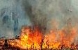 As the world watches wildfires tear through the Canadian countryside, a blaze more than twice the size rages on the other side of the world. According to an exclusive analysis of satellite data, the seasonal forest fires in eastern Russia currently cover more than a million hectares of land — making it twice as big as the roughly 500,000-hectare blaze burning in the heart of Alberta oil country. Reports from the Russian government have dramatically underplayed the scale of the abnormally severe Siberian wildfire, with officials claiming it is less than one tenth of its true size.
 Images taken by NASA satellites (Terra/MODIS and Aqua/MODIS) and obtained by Energydesk reveal huge plumes of smoke emerging from the boreal forests on the Russia-China border.

According to the Greenpeace mapping lab based in Russia, images taken by NASA satellites on May 11th show wildfires in Russia’s far east covering a mammoth one million hectares.
With more than 2 million hectares burned so far this year, 2016’s forest fires look set to become some of the largest and most damaging in recent Russian history.
The vast majority of these annual fire events are man-made, triggered by burning of vegetation for agricultural operations. Normally around 5 to 6 million hectares are burned in a year, according to Greenpeace experts, but it can get even worse than that; in 2012 it was more like 11 million. That two million hectares have already been incinerated this early in the season suggests that 2016 may become similarly devastating.